
How international shipping works
Busiest shipping lanes in the world
Key takeaways
- The busiest shipping lanes in the world are the English Channel, the Strait of Malacca, the Strait of Hormuz, the Suez Canal and the Panama Canal.
- Shipping lanes are routes across the world's oceans that vessels follow to transport goods — they are designed to avoid hazards like extreme weather, piracy, and congestion.
- A container ship takes roughly 12 to 60 days to cross the Pacific Ocean, depending on the route, vessel size and speed, weather and port stops.
Busiest shipping lanes in the world
The busiest shipping lanes in the world are the English Channel, the Strait of Malacca, the Strait of Hormuz, the Suez Canal and the Panama Canal, according to the World Economic Forum. Below is further information about each of these routes.
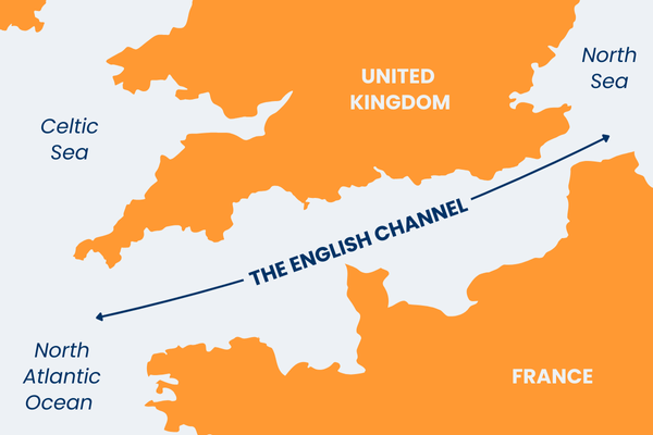
1. The English Channel
Stretching roughly 350 miles (560 km) from Land's End to the Strait of Dover, the world's busiest shipping route handles a staggering 500 vessels per day. The English Channel is a vital gateway between the Atlantic Ocean and the North Sea, facilitating trade between the UK and mainland Europe by transporting essential goods like food, fuel, and manufactured products.
At its narrowest point, the Strait of Dover (just 21 miles (34 km) wide), the route demands meticulous traffic management to prevent collisions. And despite modern navigation systems, strong tides, unpredictable weather, and high congestion make it a challenging passage for seafarers.
The English Channel is a vital gateway between the Atlantic Ocean and the North Sea...
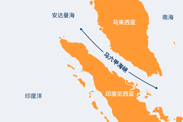
2. 马六甲海峡
南亚最受欢迎的航线 支持全球 30% 以上的贸易 — 每天约有 220 艘船只通过。这条水道延伸 580 英里 (930 公里) 横跨马来半岛和印度尼西亚苏门答腊岛,是印度洋和太平洋之间的主要航运动脉,将中国、日本和印度与欧洲和中东市场连接起来。
马六甲海峡对于能源运输至关重要,每天有超过 1500 万桶石油通过,使其成为亚洲的苏伊士运河。然而,它的浅水和流动的沙洲对超级油轮的航行构成危险,一些超级油轮在过境前会部分卸下货物。
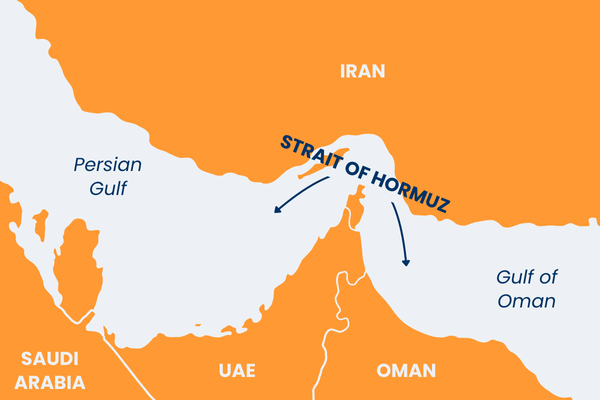
3. Strait of Hormuz
This strategically vital Middle Eastern route lies between Iran and Oman, connecting the Persian Gulf to the Arabian Sea and beyond, and handles around 103 daily vessel crossings, including 21% of the world's oil transit (some 20 million barrels per day).
The Strait, just 21 miles (33 km) wide at its narrowest point, is of such economic importance that it is considered a geopolitical flashpoint where even minor disruptions can send shockwaves through global energy markets. The presence of international naval forces underscores the region's fragile stability as nations seek to secure the uninterrupted flow of crude oil and liquefied natural gas.
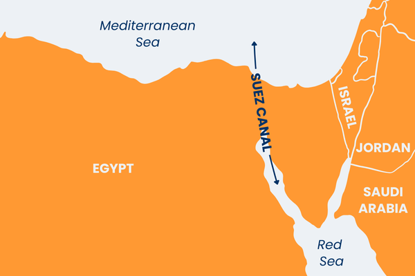
4. The Suez Canal
Approximately 50 ships pass through this artificial maritime corridor daily, cutting a 120-mile (193 km) course through the Egyptian desert to connect the Mediterranean with the Red Sea, thus slashing thousands of miles off traditional international shipping routes around Africa. The canal supports 12 to 16-hour crossings for ships moving bulk commodities like oil, grain and consumer products.
The Suez Canal is an economic lifeline for global supply chains and a testament to human engineering. However, despite recent expansion efforts to accommodate larger ships and reduce congestion, navigating the narrow, single-lane sections remains challenging, requiring precision piloting and tugboat assistance.
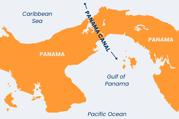
5. The Panama Canal
Another marvel of maritime engineering, the Panama Canal connects the Atlantic and Pacific Oceans through the narrow Isthmus of Panama, averaging 32 ships daily. Spanning 50 miles (80 km), this artificial waterway saves vessels over 8,000 miles (13,000 km) of travel around South America's treacherous Cape Horn, making it a linchpin of global trade.
Each year, around 14,000 vessels (carrying over 300 million tons of cargo) navigate its locks system, including the massive Neopanamax ships designed specifically to fit its expanded chambers. However, traversing the canal isn't without its challenges; strict scheduling, high tolls, and seasonal droughts affecting water levels can cause bottlenecks and delays.
What does the Suez Canal connect?
The Suez Canal connects the Mediterranean Sea with the Red Sea. Built in the mid-19th century, this artificial waterway significantly shortens cargo ship travel times by eliminating lengthy detours around Africa's Cape of Good Hope. Container ships, oil tankers and bulk carriers depend on this route to deliver goods quickly and cost-effectively. For example, a vessel from Nates, France, to Mumbai, India, via the Suez Canal spans about 6,715 nautical miles, cutting over 4,000 nautical miles and around 18 days from the same journey routed around Africa.
The canal also provides Egypt with a significant source of revenue, earning billions annually via tolls collected from every vessel passing through. The country's Suez Canal Authority (SCA) manages day-to-day operations and oversees maintenance and expansion projects, such as the 2015 widening and deepening of the canal.
What are shipping lanes?
Shipping lanes are routes across the world's oceans that shipping vessels follow to transport goods. They take specific lanes to avoid hazards like extreme weather, piracy and congestion while reducing travel time and minimising fuel use.
Certain lanes are busier due to their strategic location in global trade networks. For example, the Panama Canal, an artificial lane connecting the Atlantic and Pacific Oceans, is a popular route that significantly cuts time and costs that would otherwise be needed to navigate around South America.
High-traffic shipping lanes, also known as sea lanes, play a crucial role in global trade, as they connect manufacturing hubs like Shenzhen, Shanghai and Ruhr Valley with major consumer markets, such as the US.
As trade volumes grow, traffic congestion rises, increasing the need for innovations in shipping technology and port infrastructure. Modern ships rely heavily on advanced navigation tools, such as Automatic Identification Systems (AIS), GPS, radar and weather routing software to remain within their lanes and avoid congestion.
High-traffic shipping lanes, also known as sea lanes, play a crucial role in global trade...
How long does it take a container ship to cross the Pacific?
A container ship takes roughly 12 to 60 days to cross the Pacific Ocean, depending on the route, vessel size and speed, weather and port stops. Many ships strictly adhere to fixed schedules to ensure on-time delivery and meet the demands of the manufacturing and retail sectors.
Vessels moving from East Asia to the western United States — one of the world's busiest lanes — navigate the North Pacific, which takes at least 12 days under optimal conditions. Longer routes via the South Pacific, like those connecting South America with Asia or Oceania, generally take much longer.
According to SeaRates.com, here are some popular Pacific Ocean shipping routes, their distance and their estimated arrival times:
| Route | Distance | Est. time |
| Los Angeles, USA to Tokyo, Japan | 5,021 miles (9,299 km) | 12-40 days |
| Oakland, USA to Ningbo, China | 5,496 miles (10,178 km) | 22-39 days |
| Vancouver, Canada to Busan, South Korea | 4,985 miles (9,232 km) | 14-41 days |
| Manzanillo, Mexico to Shanghai, China | 7,209 miles (13,351 km) | 21-38 days |
| Valparaíso, Chile to Sydney, Australia | 6,230 miles (11,538 km) | 52-60 days |
Learn more about the shipping process

What is a Bill of Lading?
A Bill of Lading (BoL) is a legal document issued by a carrier or transporter of goods to a shipper to acknowledge the receipt of cargo. Learn more here.

What is a shipping container?
Here we discuss shipping container sizes and how the containerisation process works.

FCL and LCL meaning
A Full Container Load (FCL) is a shipping container filled with only your goods. An LCL (Less than Container Load) combines your shipments with others.

What are destination charges?
Destination charges for international shipping and removals explained. Read it here.

Looking for safe and secure international shipping and removals?